Click Here to Go to Map
| # | Estimated Time | Miles | Location | Comments |
|---|---|---|---|---|
| 1 | Fri 10/19/2001 01:00 PM | 0 | Entering Georgia | |
| 2 | Fri 10/19/2001 01:10 PM | 0.9 | Augusta Amphitheatre | 30-Minute Presentation |
|
The specific route in the Augusta area is:
US 1 to 5th st. exit and on to Reynolds St., west to 9th St.-James Brown Blvd. and on to the Riverwalk Amphitheater for ceremony, then after ceremony down James Brown Blvd. to Laney-Walker Blvd., west to Druid Park and on to Central Ave., west to Highland Ave., south to Wrightsboro Rd., west to Old Belair Rd. and on to James Dyess Parkway, south to Gordon Highway, west on 278 to Columbia County. The timeline for the route for key points in the city are as follows: 1:40p.m. leave Riverwalk 1:50p.m. Immaculate Conception School 2:00p.m. MCG 2:10p.m. Paine College 2:30p.m. Daniel Village 2:50p.m. Augusta Mall 3:20p.m. Ft. Gordon gate one 4:10p.m. Columbia County lineNote: Route above replaces route to point #5 on map below |
||||
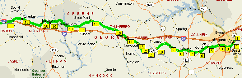
| 5 | Fri 10/19/2001 04:14 PM | 13.8 | Fort Gordon | |
| 6 | Fri 10/19/2001 05:15 PM | 18.9 | Bethel Baptist Church, Berzelia | |
| 7 | Fri 10/19/2001 06:12 PM | 23.7 | Antioch Church, Harlem | |
| 8 | Fri 10/19/2001 07:15 PM | 28.9 | Pines Apartments, Dearing | |
| 9 | Fri 10/19/2001 08:08 PM | 33.4 | Winn Dixie, Thompson | |
| 10 | Fri 10/19/2001 09:37 PM | 40.8 | Warren County Line | |
| 11 | Fri 10/19/2001 10:34 PM | 45.6 | Briarwood Academy, Warrenton | |
| 12 | Fri 10/19/2001 11:21 PM | 49.5 | Chevron Gas Station, Warrenton | |
| 13 | Fri 10/19/2001 11:54 PM | 52.3 | Norwood City Limits | |
| 14 | Sat 10/20/2001 01:06 AM | 58.3 | I-20 Overpass | |
| 15 | Sat 10/20/2001 02:33 AM | 65.6 | Crawfordville Center | |
| 16 | Sat 10/20/2001 04:52 AM | 77.3 | Amoco and Exxon Stations, Union Point | |
| 17 | Sat 10/20/2001 06:17 AM | 84.4 | Ingles Store, Greensboro | |
| 18 | Sat 10/20/2001 07:22 AM | 89.8 | Oconee National Forest (Bridge) | |
| 19 | Sat 10/20/2001 09:08 AM | 98.7 | Buchhead Road, Buckhead | |
| 20 | Sat 10/20/2001 10:02 AM | 103.2 | Madison | |
| 21 | Sat 10/20/2001 12:07 PM | 113.7 | Rutledge | |
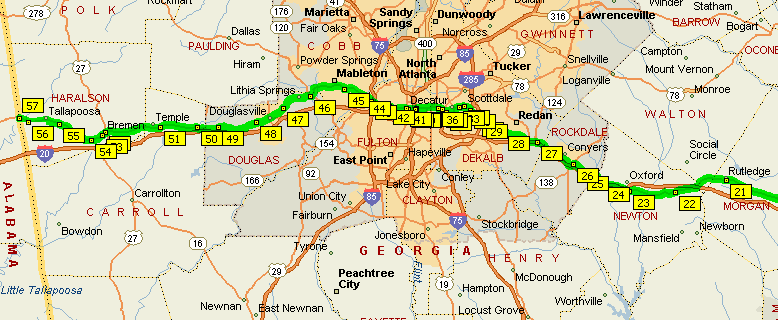
| 22 | Sat 10/20/2001 01:40 PM | 121.5 | Hub Junction | |
| 23 | Sat 10/20/2001 03:03 PM | 128.4 | Covington | |
| 24 | Sat 10/20/2001 03:49 PM | 132.3 | I-20 | |
| 25 | Sat 10/20/2001 04:33 PM | 136.0 | Almon | |
| 26 | Sat 10/20/2001 04:56 PM | 137.9 | Hwy 162, Conyers | |
| 27 | Sat 10/20/2001 06:16 PM | 144.6 | Turner Hill | |
| 28 | Sat 10/20/2001 07:28 PM | 150.6 | Belmont | |
| 29 | Sat 10/20/2001 08:14 PM | 154.5 | Glen Haven | |
| 30 | Sat 10/20/2001 08:23 PM | 155.2 | Cub Foods, I-285 | |
| 31 | Sat 10/20/2001 08:43 PM | 156.9 | Hwy 154 | |
| 32 | Sat 10/20/2001 08:55 PM | 157.9 | Avondale City Hall | |
| 33 | Sat 10/20/2001 09:04 PM | 158.7 | Sam's Crossing | |
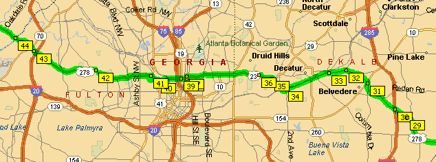
| 34 | Sat 10/20/2001 09:27 PM | 160.6 | East Lake Transit Station, Decatur | |
| 35 | Sat 10/20/2001 09:43 PM | 161.9 | Ponce de Leon Manor NE, Atlanta | |
| 36 | Sat 10/20/2001 09:49 PM | 162.4 | Fernbank Museum, Atlanta | |
| 37 | Sat 10/20/2001 10:26 PM | 165.5 | Juniper Avenue, Atlanta | |
| 38 | Sat 10/20/2001 10:27 PM | 165.6 | Noth Avenue, Atlanta | |
| 39 | Sat 10/20/2001 10:29 PM | 165.8 | Varsity on North Avenue, Atlanta | Break (30 Minutes) |
| 40 | Sat 10/20/2001 11:14 PM | 166.8 | Northside Drive, Atlanta | |
| 41 | Sat 10/20/2001 11:25 PM | 167.6 | Hwy 278 (left turn) | |
| 42 | Sun 10/21/2001 12:05 AM | 170.4 | Bankhead Highway | |
| 43 | Sun 10/21/2001 12:46 AM | 173.3 | I-285 | |
| 44 | Sun 10/21/2001 01:02 AM | 174.4 | Cobb County Line, Chattahoochee River | |
| 45 | Sun 10/21/2001 01:52 AM | 177.9 | Leland Plaza, Leland | |
| 46 | Sun 10/21/2001 03:17 AM | 183.8 | Advance Auto Parts, Austell | |
| 47 | Sun 10/21/2001 04:24 AM | 188.5 | Douglas County Fire Station #7 | |
| 48 | Sun 10/21/2001 05:25 AM | 192.8 | Bill Arp Road, Douglasville | |
| 49 | Sun 10/21/2001 06:48 AM | 198.6 | Before Nalley Road | White shack on right |
| 50 | Sun 10/21/2001 07:34 AM | 201.8 | Chevron/Golden City Market, Villa Rica | |
| 51 | Sun 10/21/2001 08:53 AM | 207.3 | Carroll County Fire Rescue, Temple | |
| 52 | Sun 10/21/2001 10:47 AM | 215.3 | Bremen Marine, Bremen | |
| 53 | Sun 10/21/2001 10:56 AM | 215.9 | Mark Lyn Foods, Bremen | |
| 54 | Sun 10/21/2001 11:22 AM | 217.7 | Shell, Waco | |
| 55 | Sun 10/21/2001 12:36 PM | 222.9 | Tally Valley Campground, West Crossing | |
| 56 | Sun 10/21/2001 01:40 PM | 227.4 | Tallapoosa River Bridge, Hooper | |
| 57 | Sun 10/21/2001 01:00 PM | 228.8 | Entering Alabama | Central Daylight Time |